Augmented Reality was initially used for military, industrial, and medical applications, but was soon applied to commercial and entertainment areas as well. In the cultural sector, it can be of particular relevance in the fields of archaeology, architecture, art, city planning, for applications in tourism, education, social innovation… At the moment, the most relevant applications for cultural field are webcam augmented reality and mobile (or handheld) augmented reality. They provide enriched, interactive and digitally manipulable information.
CultureClic | Augmented culture
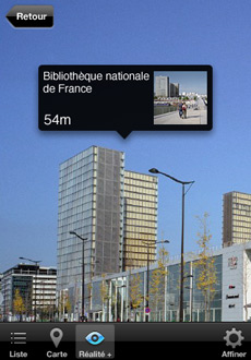 CultureClic is a mobile cultural application to discover geolocated works of arts in high definition, to access to french museums information, and to discover cultural events, through augmented Reality:
- 900 art works geolocated (mainly in Paris) are accessible in Augmented Reality, and through map and lists.
- Thanks to the Réunion des musées nationaux (RMN) catalogue and Bibliothèque Nationale de France (BNF – French National Library) archives, users can discover how the places were several centuries before: the building of the Eiffel Tower, the first pictures of Notre-Dame…
- 1350 French museums are geolocated, with their practical information and cultural offer.
For now, the application is available on IPhone, and will be soon available on other platforms. This project has been developed by the Living Lab e-marginal, for Proxima Mobile, in cooperation with BNF, RMN and French Ministry of Culture and communication.
HistoryPin | Pin your history to the world
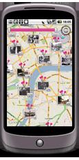 HistoryPin is a collaborative website and application, offering the opportunity for people to share and explore personal archives and memories. Everyone can add geolocated photographic images, videos, audio clips and descriptive and narrative text. HistoryPin is collaborating with over 200 libraries, archives and museums around the world to help them share their content with a global community of users. The main long-term objectives of this project are the followings:
- To get as many people as possible taking part in the history of their family, streets, country and world.
- To bring neighbourhoods together around local history and help people feel closer to the place they live in.
- To get people from different generations talking more, sharing more and coming together more often.
- To conserve and open up global archives for everyone to enjoy, learn from and improve.
- To create a study resource for schools and universities.
- To be the largest global archive of human history.
The website allows exploring the map and adding content. Thanks to the application, people can explore the map, add content, but also explore the streets: the app uses the camera view to display nearby images. By selecting the image, it can be overlaid onto the modern view to create an historical comparison.
This project has been developed by We are what we do, a not-for-profit company based in London, www.wearewhatwedo.org
CYNETART AR POP UP CITY Dresden| Augmented and mixed reality: Parcours
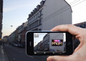 CYNETART, the international festival for computer based art in Dresden, is a countrywide and internationally recognised platform of digital culture – providing an in-depth overview of current developments of technology-based art. It will take place from 15th to 21st November 2012. In this framework, a specific programme is dedicated to the exploration of the city of Dresden through Augmented Reality.
Various virtual projects will make the city become a sensitive experience, between physical and virtual world, through the cost free LAYAR-app.
It is a cooperation between computer scientists and media designers from TU Dresden. Artists and TU students works in tandems on different approaches of border-crossing use of Augmented Reality technology. Throughout collaborative work they question social and artistic potential of it.
http://t-m-a.de/cynetart/f2012/cynetart-arpop-up-city?lang=en
UAR | Urban Augmented reality
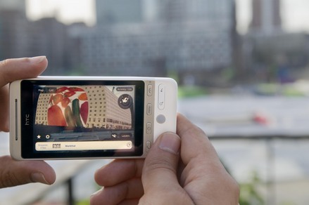 This architecture application has been developed by the Netherlands Architecture Institute (NAI). It provides information about the build environment, through texts, images, archives. By means of advanced 3D models, UAR shows the user what is not there: The city as it once was – for instance by showing buildings that once stood there. The city as it might have been – by showing scale models and design drawings of alternative designs that were never implemented. And the city of the future – by showing artist’s impressions of buildings under construction or in the planning stage.
UAR was originally created to make the NAI collections available. It has now become a broad mobile platform for architecture and urban design, in which numerous parties cooperate: architecture centres, firms of architects, art institutions, municipal archives, museums, local authorities and market parties.
UAR is available in 8 cities in The Netherlands includingRotterdamandAmsterdamand is still growing. Since the beginning of 2011 there is an English-language version, and users can add objects themselves, such as their own home or other unusual buildings. The application is free and collaborative: users add content and thereby contribute to the expansion of the database. Users can also correct one another.
UAR is a collaboration between NIA, Agentschap NL, the BankGiro Loterij, the VSB fund and SNS Reaal. UAR was developed in cooperation with IN10 Communicatie, Layar and DPI Animation House.
http://en.nai.nl/museum/architecture_app
Reflections and experimentations are led on future AR applications, evolving very fast. Linked Data and open data have a strong potential to enrich them, and will be an important component in future developments. However, whatever new applications may provide, it is obvious that AR technology itself is not enough to create real users’ experience: it is a tool, the content has priority.
See also the experimentations led by Dedale, in the framework of the Smart City Living Lab, on digital urban services for mediation, heritage and tourism applications: http://www.smartcity.fr


 If you have interesting news and events to point out in the field of digital cultural heritage, we are waiting for your contribution.
